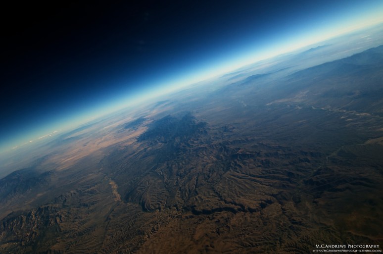
The Aerial Horizon
Forget where your feet are and simply enjoy the view.
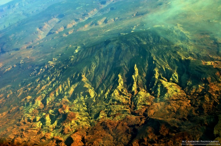
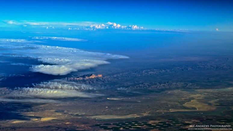
As the cloud deck drapes the planet in obscurity, we observe a metaphor for our perception of the world around us. When the clouds part, the veil of our limited perception is lifted and we catch a glimpse of some holy place on the earth below. There are moments when we recognize the significance of what has been revealed but we can only express it in our “sense of awe.” Navajo Mountain in Utah is one such place, a holy protrudence of earth that amazes the soul.
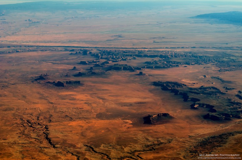
The atmosphere is “crisp” in the Autumn air and we experience a detailed perspective on the landscape. In Monument Valley, Utah the details of the stone monuments are distinct. Train Rock stands in the foreground as we look toward Eagle Mesa and the valley beyond.

Chances are that you missed this as the Mid-Atlantic became overcast just before sunset last night…This brilliant sunset began between cloud layers as we climbed through the dark overcast and disappeared below the aerial horizon somewhere over New Mexico…On the other hand, if you have a job where you sit in front of a big window and see the world from 30,000 feet, you might have shared this view with us last night. Cheers.
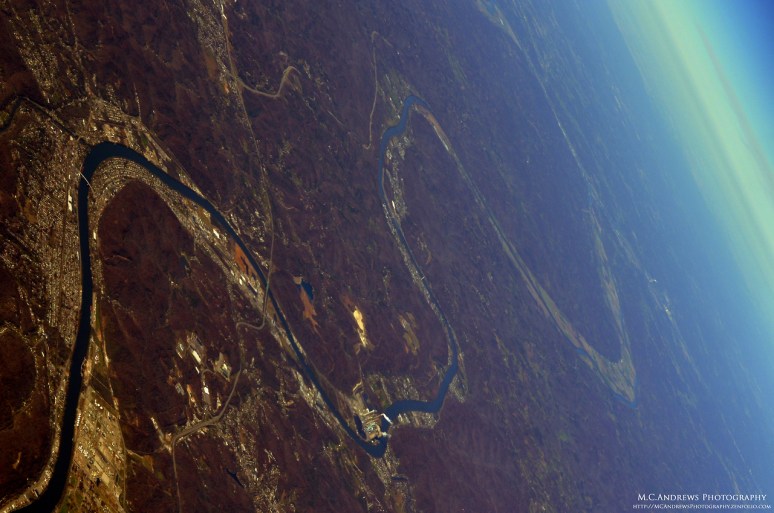
The Kanawha River winds through the mountainous terrain of West Virginia toward Charleston. The stacks of power plants are visible waypoints marking the development along the waterways.
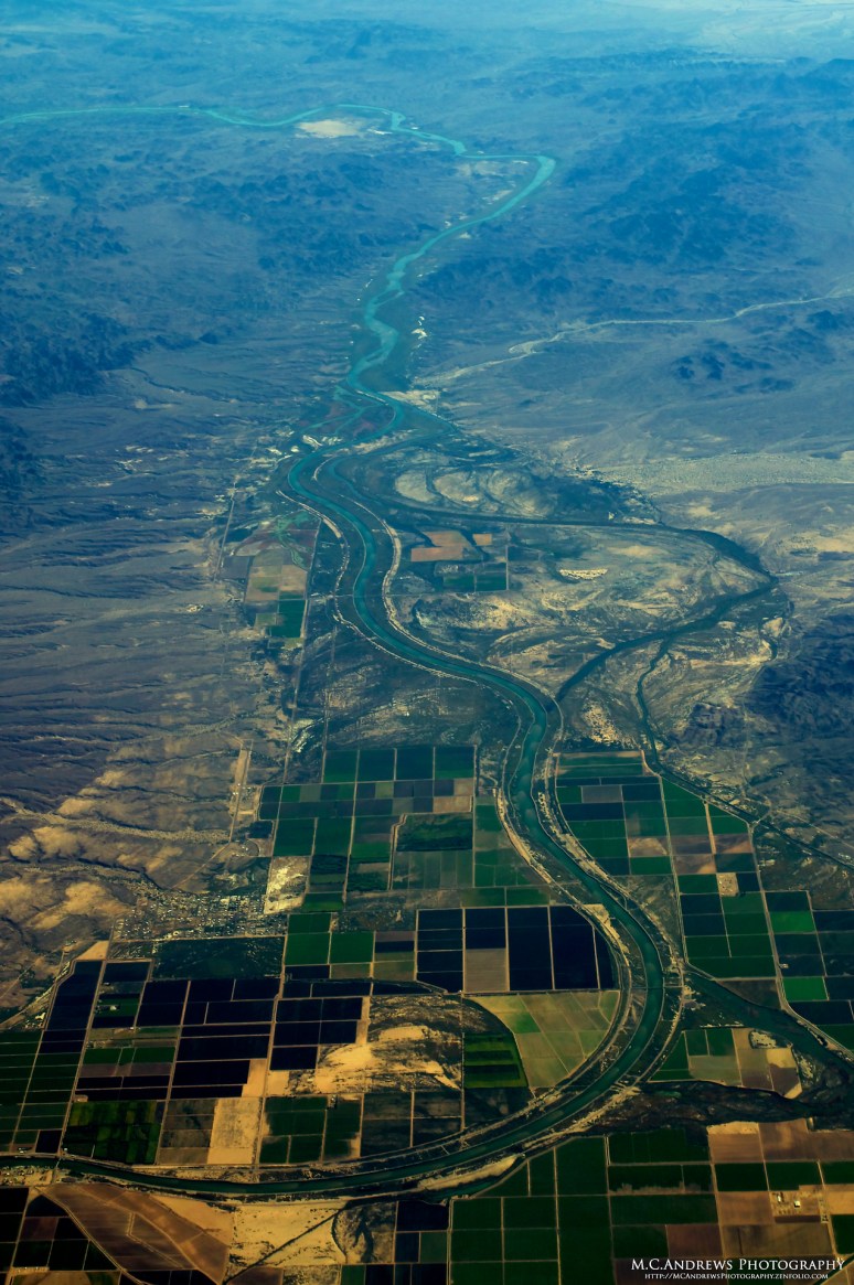
The Colorado River runs south of Blythe, California through the town of Palo Verde. The water runs southward following graceful sculpted curves along the the desert floor. The river fuels the adjacent agricultural areas creating an oasis-like scene amid the arid landscape.
On the floor of the Sonoran Desert in southwestern Arizona it is difficult to tell that it is Autumn in North America…however the crisp and dry autumn air creates a wonderful view of the abstract erosion as we look through the atmosphere. Rain is infrequent here and it is always a “gully washer” when it comes and makes its mark upon the desert. Ridges are revealed and deep grooves flow and spread amid the pinnacles of rock.

The sinking sun casts shadows on the eastern faces of the Appalachian Mountains of West Virginia. Meanwhile, the view from the west is saturated with a deep red hue and Moorefield, West Virginia and the south branch of the Potomac River come into focus to the east. Always, the deep grooved valleys remind us of the glacial movements that created this amazing view.

As Autumn peaks, so do the colors of the foliage along the Blue Ridge Mountains of Virginia. As we turn toward Culpeper, the change in foliage density along the ridgeline reveals Skyline Drive running southward. The deep yellows and reds of the trees give the mountains a texture of velvet that will soon stiffen and disappear as Winter approaches.
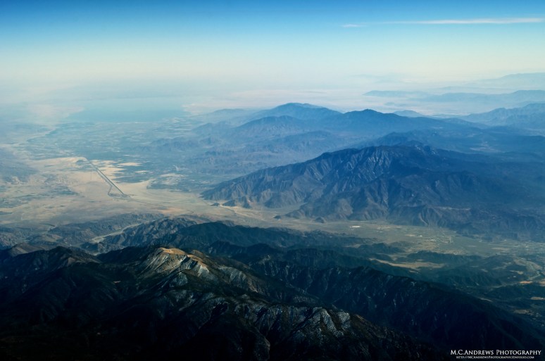
A light dusting of autumn snow adorns the peak of San Gorgonio Mountain. Mount San Jacinto stands beyond the San Gorgonio Pass. The two giant hills marking the passageway into Southern California. As we turn southeast, our eyes follow the highway toward Palm Springs and the desert beyond.

The Franklin Mountains lie between New Mexico and Texas. The mountains in this small range are referred to as tilted-block fault mountains. As we fly over, we simultaneously see Las Cruces, New Mexico to the west of the range and El Paso, Texas to the Southeast.
As we leave El Paso, Texas behind us, the white stone edifice of the Guadalupe Mountains comes into view. The contrast of the sheer white rock face to the flat sandy Chihuahuan Desert floor gives the mountain a dreamlike appearance as if depicted in an ancient myth. At the south end of the Guadalupe Mountains National Park, Guadalupe Peak stands 8,751 feet above sea level and is the highest natural point in Texas. There is a stainless steel Pyramid atop the peak that was erected by American Airlines in 1958 to commemorate the 100th anniversary of the Butterfield Overland Mail whose riders once carried mail south of the peak.
Aravaipa Canyon arcs around the northwest end of the Galiuro Mountain range and intersects the Gila River to the west. The Aravaipa Canyon Wilderness area covers 19,410 acres of irregular contours and outcroppings from the desert landscape of Arizona.

Over the desert of northwestern New Mexico a traffic advisory call is made to two 737s, two pilots roger up and their flight paths cross. With advances in technology allowing more aircraft to operate safely in finite airspace, a vigilant commitment to our “see and avoid” doctrine is more important than ever. Keep your heads up and looking outside the cockpit and fly safely.
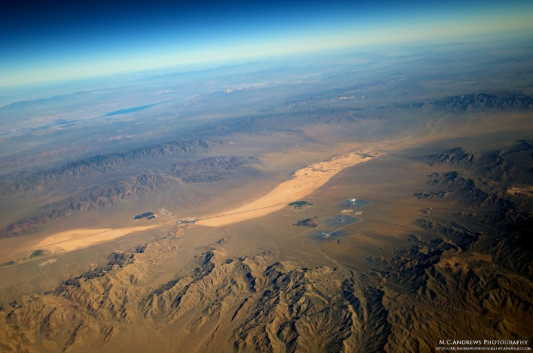
On the barren landscape of Ivanpah Dry Lake in the Mojave Desert, the solar collectors of the Ivanpah Solar Electric Generating System appear to be from another world. Harnessing the one abundant resource in the desert, this unique landmark may be one part of a solution to providing renewable clean energy to the power grid of the western US.
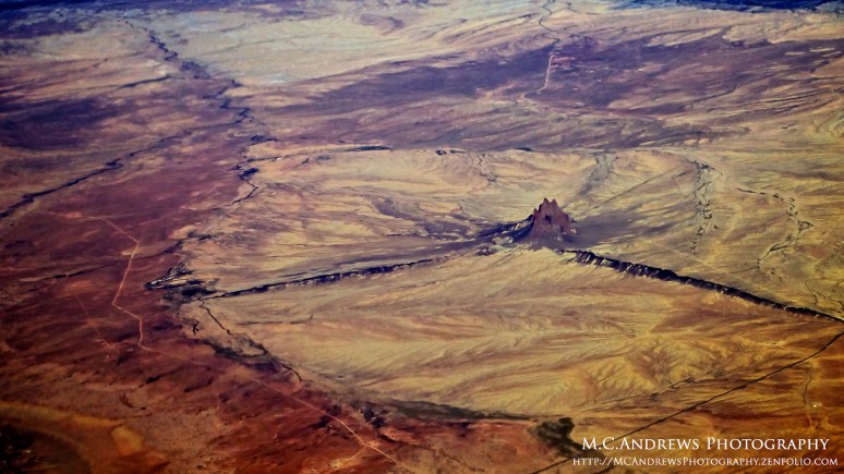
Shiprock commands a 360 degree view of the desert plain in the Navajo Nation located in San Juan County, New Mexico. A monadnock, it stands over 1500 feet above the otherwise flat desert plain. Shiprock’s unique and multi-faceted shape make it easy to identify as its form takes shape on the horizon.

After crossing the Painted Desert and admiring the irregular colors and patterns, the terrain takes on a more consistent burnt umber hue…until the deep red tones in the cliffs around Sedona come into sight. The color pops out of the landscape as if shouting, “Look over here and be amazed!” The color is noticeable from over a hundred miles away and gradually the contours appear. From the air these cliffs and canyons amaze us, but the people in Sedona must be in a perpetual state of awe at the majesty of these rocky forms.

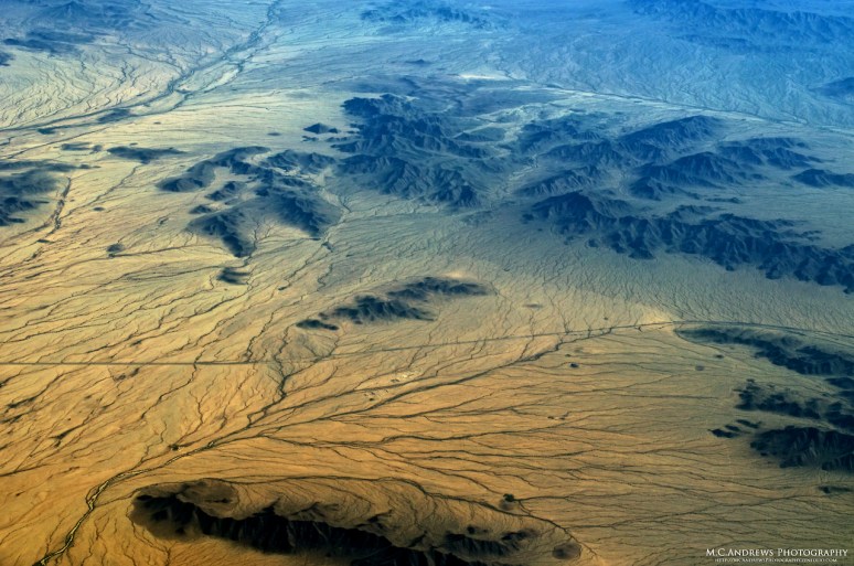
West of Lake Havasu en route to Twentynine Palms, the combined effects of wind and water have feathered the rivulets of this riverbed in California’s Mojave Desert. Beautifully abstract, nature brushes its effects to create art on the sandy desert floor.

Overhead Big Hole National Battlefield we cast a reverent glance southward to watch snowcapped Bitterroot Range tracing the border of Idaho and Montana as it sprawls toward the horizon. This is a magical place as each deep valley is world unto itself, separated by crisply defined ridges and mountains. This is the land of the Nez Perce.

The Missouri River twists and turns through the plains of South Dakota east of Pierre. In the absence of contours, the river provides a welcome visual break from the flat earth checkered with rectangular farms.
Get ready, it’s coming… This is the snow line across the northwest corner of South Dakota. While we are already seeing consistent snowfall in the mountains, this is the first clear indication of snow in the plains. Although it appear like a gentle dusting, soon this massive expanse of land will be covered with dense snow.
The Aerial Horizon – Photography

